
The United States is one of the world’s leading wind energy producers. A wind map of the USA shows wind speed, wind zones, wind power capacity, and wind energy resources across all 50 states. Our collection of 8 free printable US wind maps covers everything from basic wind zones to detailed wind energy and resource maps.
List of the United States Wind Map :
1. U.S Wind Map:
2. U.S Wind Zone Map:

3. U.S Wind Power Map:

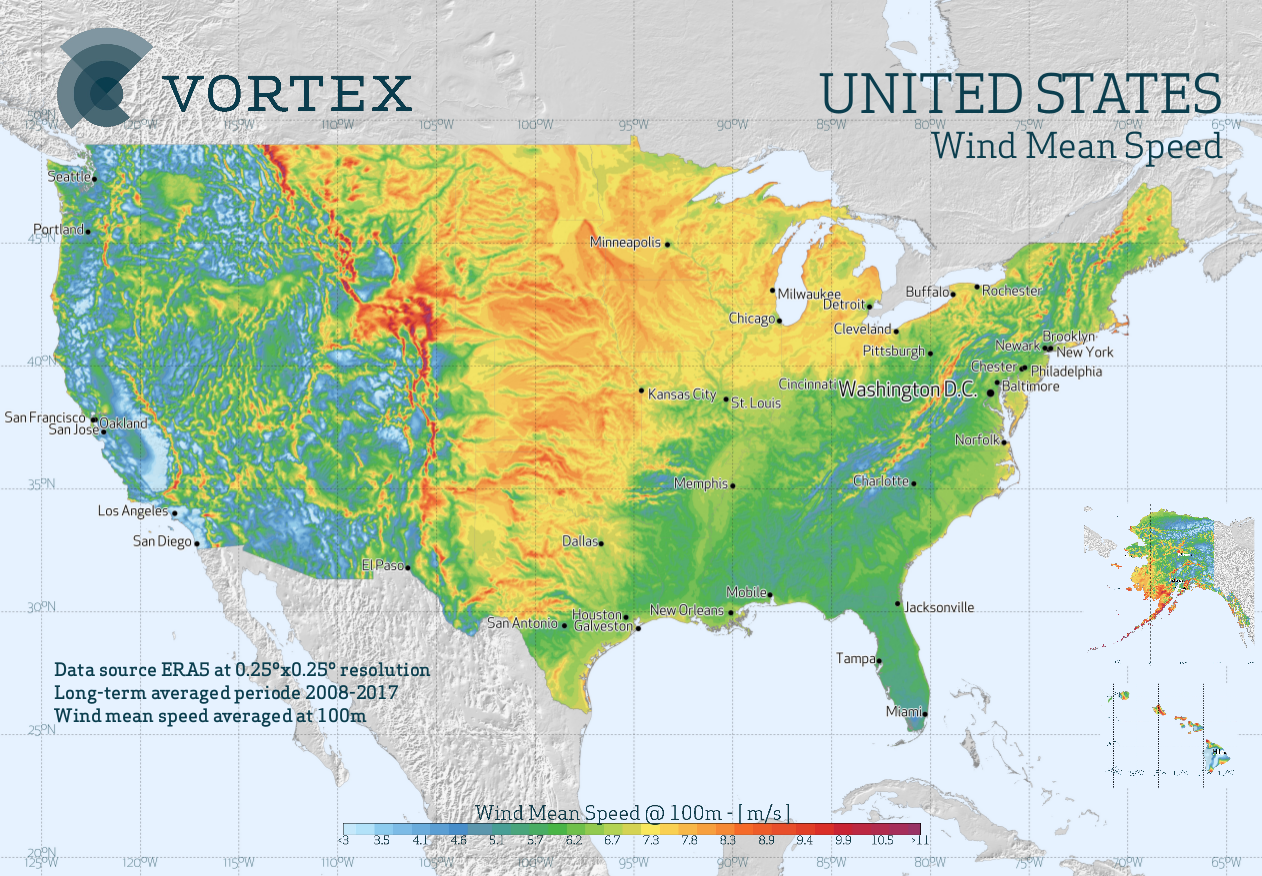
4. U.S Wind Speed Map :

5. U.S Wind Energy Map:

6. U.S Wind Resource Map:

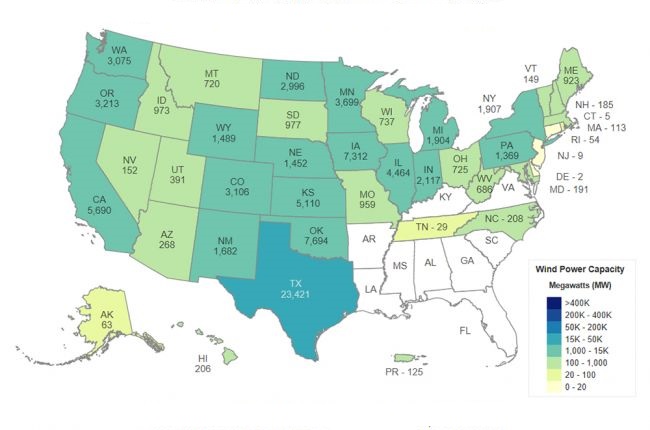
7. U.S Wind Power Capacity Map:
8. America Wind Map:
We have defined 8 types of maps above, which you must have seen. You can use them according to your needs. Mostly, they are used in school projects or by researchers. For your information, let us tell you that wind turbines are more complex machines than traditional windmills. A wind turbine consists of 8,000 different components. Its blades average 200 feet long, and turbine towers average over 300 feet tall. You can think of it as the height of the Statue of Liberty.
It is being used more and more, which means more power than wind speed. The average capacity of utility-scale wind turbines installed in 2021 was 3 megawatts (MW), up 9% from the previous year. They are being elongated to reach a higher height from the ground so that these turbines can spin faster in more air. So that more and more energy can be generated.
To find the average wind speed in your state or hometown, see the Department of Energy’s wind resources wind map of US and learn more about the opportunities for tall wind turbines in a report from the Department of Energy’s National Renewable Energy Laboratory. Many components of wind turbines installed in the US are manufactured by more than 500 wind-related manufacturing facilities nationwide.
The wind industry currently employs approximately 120,000 people. Utility-scale wind power (from turbines over 100 kW) is installed in 41 states. All 50 states and the District of Columbia, Puerto Rico, Guam, and the U.S. Virgin Islands have installed wind.
We have shown all types of maps according to your needs. Like wind energy, speed, power, zone, etc. You can download these images for free. You do not need to pay any payment for this. All these images are printable; you can also print them out on the printer.
US Wind Energy — Key Facts
The United States is a global leader in wind energy. Here are key facts about the US wind industry shown in our maps above:
- Wind turbine components: A single wind turbine has over 8,000 parts
- Blade length: Average 200 feet long
- Tower height: Over 300 feet tall
- Average capacity (2021): 3 megawatts (MW) per turbine — up 9% from the previous year
- Jobs: The wind industry employs approximately 120,000 people in the USA
- States with wind power: Utility-scale wind is installed in 41 states
- Top wind states: Texas, Iowa, Oklahoma, Kansas, and Illinois lead in wind energy production
Map #2 (Wind Zone Map) shows which areas have the strongest wind resources. Map #6 (Wind Resource Map) is the most detailed for identifying high-potential wind energy locations.
If we have left any wind map US that you need for your project or research, then be sure to let us know via comment or email. So that we can define that map in front of you as quickly as possible. All our articles will solve the problem related to your map. So help in their project by sharing it with as many schools and college friends as possible. You can also share these maps with those who have to do some research.
Frequently Asked Questions
Q1: Which US state produces the most wind energy?
Texas produces more wind energy than any other US state, accounting for about 26% of all US wind power generation. Iowa is second and gets over 57% of its electricity from wind — the highest percentage of any state.
Q2: What are the windiest states in the USA?
The Great Plains states — Kansas, Oklahoma, Nebraska, North Dakota, and South Dakota — have the strongest average wind speeds in the continental USA. These states have ideal conditions for wind energy production.
Q3: How many wind turbines are in the USA?
The United States has over 70,000 wind turbines installed across 41 states. Texas has the most wind turbines of any state, followed by Iowa and Oklahoma.
Q4: Can I download these wind maps for free?
Yes, all 8 wind maps are completely free. Click the PDF button under any map to download it instantly.


