
As we have told you many times before that the United States of America is counted among the big countries in the country. And it is a combined unincorporated and organized sector. People who want to visit the islands and get information about them. How does this island look and in how much area it is spread? Their search will end on our website because we have defined the US virgin islands map below.
United States Virgin Islands Map Collections :
1. U.S Virgin Islands Map:

2. U.S & British Virgin Islands Map:

3. Virgin Islands National Park Map:

4. U.S.A Virgin Islands Map:
5. Virgin Islands on World Map:

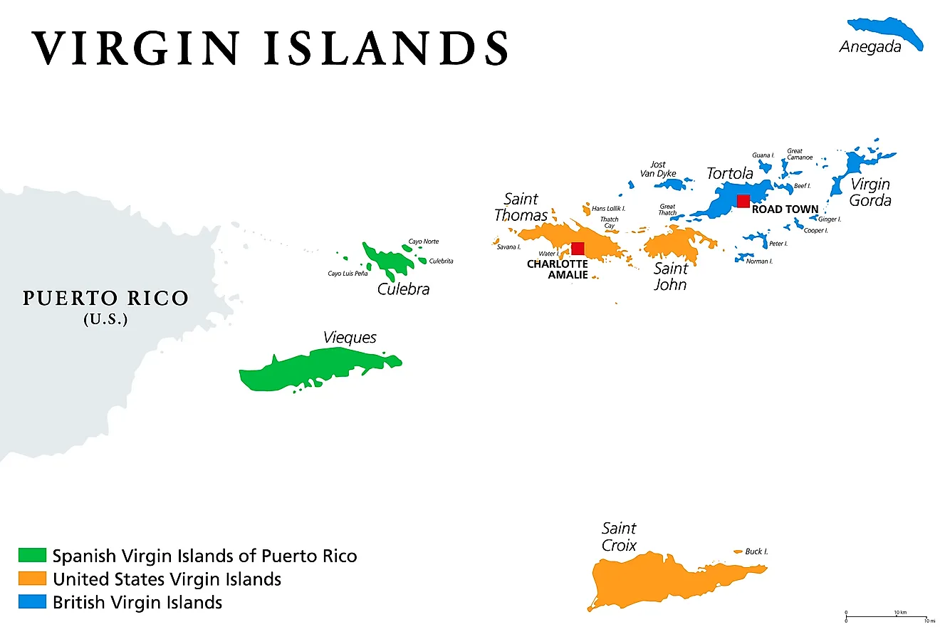
We have shown 5 types of maps in our table above. Which you can use according to your need. For your information, let us tell you that the United States Virgin Islands, generally the Virgin Islands of the United States, is a group of Caribbean islands. The islands are geographically part of the Virgin Islands and are located in the Leeward Islands of the Lesser Antilles, east of Puerto Rico and west of the British Virgin Islands. Which you can see in our first image.
The islands formerly known as Denmark-Norway (from 1754 to 1814) and the Danish West Indies of the Free Kingdom of Denmark (from 1814 to 1917) were sold by Denmark to the United States for $25,000,000 in a 1917 treaty. The Danish West Indies has since been an organized, unincorporated United States territory. The US Virgin Islands are organized under the Virgin Islands’ Revised Organic Act of 1954 and have held five constitutional conventions since then.
The USA Virgin Islands were originally inhabited by the Siboni and the Arawaks. Some people believe that the islands have been inhabited since 1000 BC. The Carib arrived in the middle of the 15th century. The Virgin Islands cover an area of 133.73 square miles (346.36 km2) of land. Around it are 50 other smaller islands and cays. Its capital is Charlotte Amalie on the island of St. Thomas. Which you can see in our image at number 4.
About the US Virgin Islands (USVI)
The US Virgin Islands (USVI) is an unincorporated territory of the United States located in the Caribbean Sea, about 40 miles east of Puerto Rico and 1,100 miles southeast of Miami, Florida.
3 Main Islands:
St. Thomas — The most populated island and home to the capital Charlotte Amalie. Known for its beautiful natural harbor, duty-free shopping, and beaches like Magens Bay. Area: 32 square miles.
St. Croix — The largest island at 84 square miles. Has two main towns — Frederiksted and Christiansted. Known for its flat terrain, beaches, and rum production.
St. John — The smallest main island at 20 square miles. More than two-thirds of the island is protected by the US National Park Service. Known for pristine beaches like Trunk Bay.
Key Facts
- Capital: Charlotte Amalie (St. Thomas)
- Total Area: 133 square miles
- Population: ~102,000
- Currency: US Dollar
- Language: English
- Became US Territory: 1917
- Highest Point: Crown Mountain, St. Thomas at 1,555 feet
It is very easy to download these united states virgin islands map. You have to download these maps in your finished phone or computer by clicking on the PDF button without paying any payment. All these images are printable and can be printed out through the printer and used in your research or school projects.
Frequently Asked Questions
Q1: Where are the US Virgin Islands located?
The US Virgin Islands are located in the Caribbean Sea, approximately 40 miles east of Puerto Rico and about 1,100 miles southeast of Miami, Florida. They consist of 3 main islands — St. Thomas, St. Croix, and St. John — plus about 50 smaller islands and cays.
Q2: Do US citizens need a passport to visit the US Virgin Islands?
No. US citizens do not need a passport to visit the US Virgin Islands, as it is a US territory. A government-issued photo ID is sufficient for travel from the continental United States.
Q3: What is the capital of the US Virgin Islands?
Charlotte Amalie on the island of St. Thomas is the capital of the US Virgin Islands. It is known for its excellent natural harbor and is a popular cruise ship destination.
Q4: Can I download these Virgin Islands maps for free?
Yes, all maps are completely free. Click the PDF button under any map to download instantly.


