
In today’s generation maps are needed by someone or the other because most of the maps are used by the students in the school to complete their project or to know the places located on them. The same people also use the map to roam when they go astray from their path. Here you will get to see the printable map of the United States, which you can download or print out according to your need. We have made a list of such maps which you can see below:
List of the Printable U.S.A Map :
1. Labeled Printable Color U.S States Map:

2. U.S Map with State and Major cities:

3. U.S Map with all Cities:
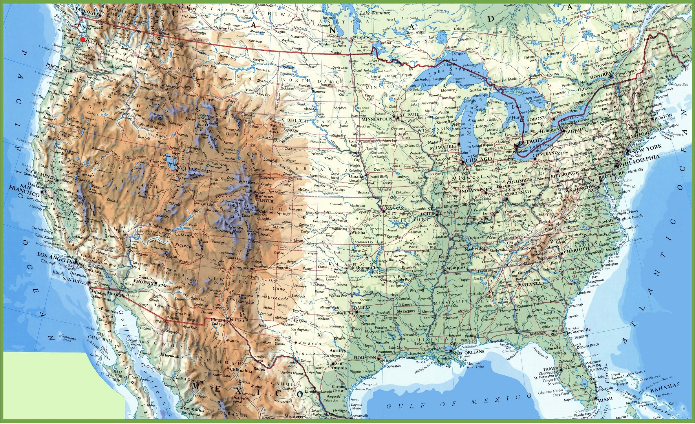
4. U.S Blank Map with no State Boundaries:

5. Labeled Printable U.S States Map:

6. U.S Map Black and White Printable:

7. Blank Map United States with color:

8. Printable Blank Map of the United States :

9. U.S State Colorful Map:

10. Outline Map of the United States:

11. Map of Southeast United States:

12. Western United States Map:

13. United States Map In Flag shape:

14. United States Map with Capitals Only:

15. U.S Map with State and Capital:

Maps are very useful for travelers, teachers, students, geography studies, some projects, and other types of research. That’s why we have prepared a list of every type of map for you so that you can solve your problem. We all know that the U.S.A is one of the big countries in the world and we have shown the maps of this country in different ways. So that you can use it in your projects. For those who want printable US state map, we have shown them in color and without color, you can do it according to your own accord.
You can see this list of 15 maps, in which each of the maps can be used in a different way in your project or schoolwork. In this, a printable map of the united states with state names has been placed on the first and fifth numbers, we have also shown this map in 2 types. In color and 2nd Without color. Because some people want a US map with states in color so that they can easily download it and use it in their project. And some people need a color map so that they can fill color according to them and use it.
If you want a printable US map with cities for your project then you don’t need to go to any other website because we have included that map also in our list. With us map with cities, you will get 2 maps which we have shown with different types. This will help you to know which city is in which state. And through these maps, you will also be able to remember their names. If you are a teacher, it can also help you teach students about Cities maps of the United States.
On the 10th number, you will see a printable outline map of the united states which will be very helpful for the student. If you have learned the state names and you want to practice them, then this measurement is perfect for you. You can download it for free and practice by entering the state name in it. You can easily get these maps or take a printout by pressing the PDF button shown.
Printable US Map with Capitals :
If you want a U.S map State with capitals together and you’ve been looking for it for a long time, it’s available here. The printable US map with states and capitals is shown in the picture below. As you can see at the last of the list. In which you will see the maps of the capital. If you are researching information related to the United States, then this can help you to make research more interesting by providing all the information you need.
We have shown here all types of maps of the United States of America except rivers and creeks. You can see the preview of the map in the given image. If you want to download the map then you have to click on the PDF button. By which that map will be downloaded to your mobile or computer in PDF format. You don’t need to pay to get all these maps. These maps are free to all. Which you will not find on any other website. All you have to do is click on the PDF button shown or you can connect any of your smart devices to your printer to take the printout.
I think you must have liked my list of free USA map printables in which I have shown all map-like free printable US map with cities and free printable USA maps with states. Apart from this, if you have any other queries, then you can tell us through a comment or send mail. We will definitely solve your problem.
How to Download and Print These USA Maps
Downloading these maps is very simple. Each map in our list has a PDF button directly below it. Click that button and the map will download to your smartphone, tablet, or computer. Once downloaded, open the PDF and press print. These maps are optimized for standard US Letter and A4 paper sizes, so they print cleanly without cutting off edges. For best print quality, use a color printer for maps #1, #7, and #9. For black and white printers, maps #6, #8, and #10 are ideal choices.
Frequently Asked Questions (FAQs)
Q1: Can I download these USA maps for free?
Yes, all maps on this page are completely free to download. Simply click the PDF button below any map image to download it directly to your device.
Q2: Are these printable USA maps suitable for students?
Absolutely. These maps are perfect for school projects, geography homework, and classroom activities. The blank and outline maps are especially useful for practice.
Q3: Which USA map is best for a school project?
For school projects, the labeled color map (Map #1) or the US map with states and capitals (Map #15) is most popular. For blank practice maps, use Map #4 or Map #8.
Q4: Can I print these maps at home?
Yes. All maps are in PDF format and can be printed on standard A4 or Letter-size paper using any home or office printer.
Q5: Is there a printable USA map with cities and states both?
Yes! Map #2 shows both states and major cities together. Map #3 shows all cities across the US.


