
Those who are interested in the Maps article related to the environment and you are a citizen of the United States, then you are at the right place because we have defined maps related to nature, related to temperature on our website. Today we are going to define the US snow cover map in front of you. You can see the maps related to it in the list below.
Collection of the Snow Cover Map of US :
1. U.S Snow Cover Map:
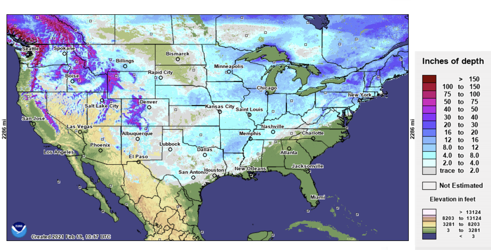
2. U.S Snow Depth Map:

3. Printable U.S Snow Cover Map:

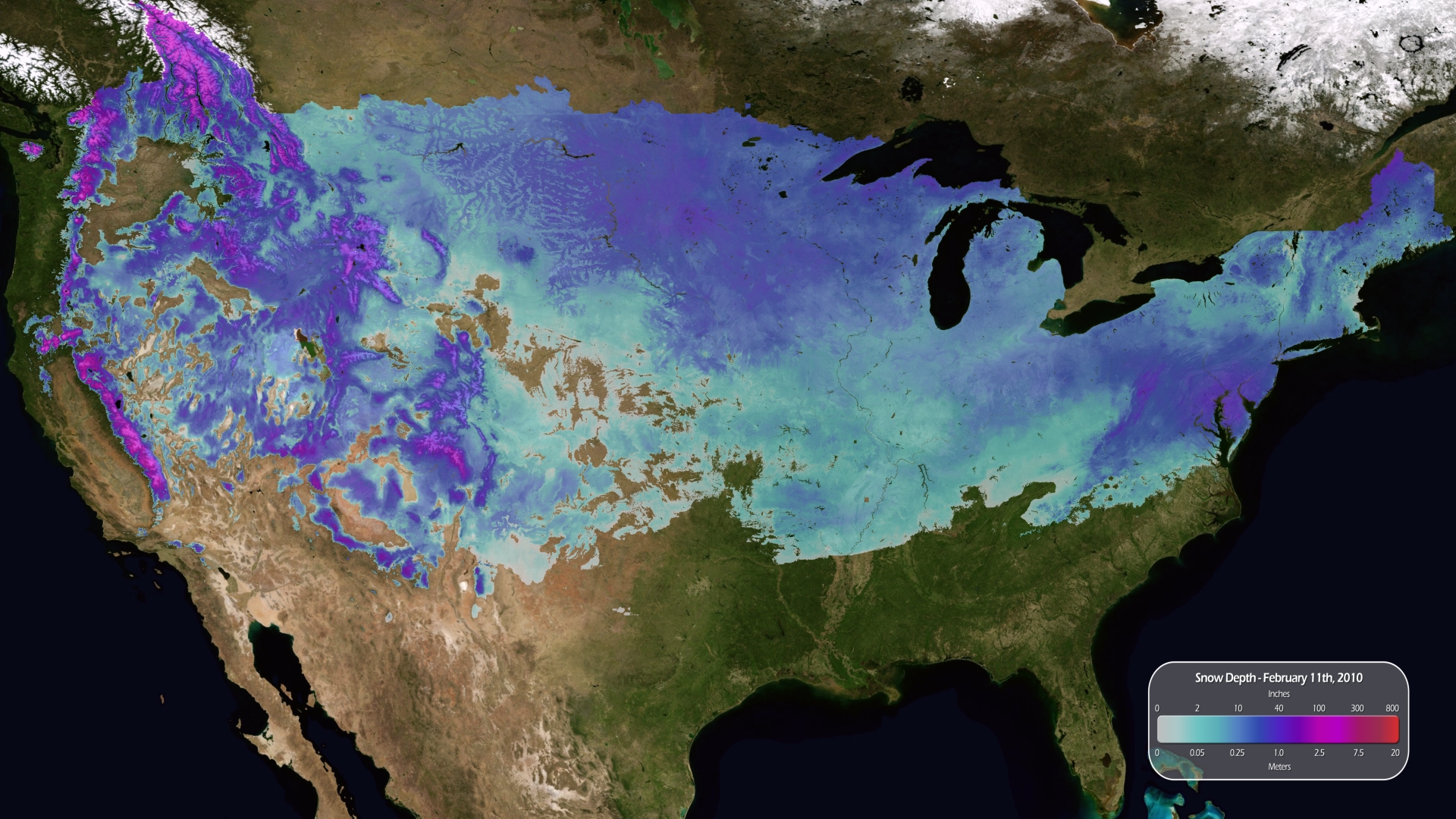
4. U.S Snowfall Map :
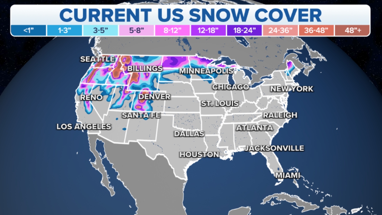
5. Current U.S Snow Cover Map:
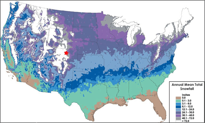
6. U.S Snow Cover Map Yearly:
We’ve defined 6 types of snow maps above that you can use to predict the area covered by snow in the United States. Through these maps, you can estimate the amount of snowfall and can make people aware of the upcoming event in advance. Because you can do this through a snow cover map of the current year and last year.
You can find out how much of the United States is covered with snow by looking at our 4th image. For your information, let me tell you that on average, about 70% of the United States experiences some snowfall during the winter season, though the amount varies greatly by state and region. These maps of US snow cover will help you to know the amount of snowfall, which can be predicted through the weather forecasts.
From these maps, children will get complete information about the snowfall in their country, so that they can use all these images in their projects or research. And you can increase your knowledge. The amount of snowfall is higher in the United States than in other countries. We have also defined the snow cover map of the last year, which you can see at number 6th.
We have included all the states in this snowfall map of USA so that you can know stats-wise all about which states are covered by snow. With their help, people can deal with the situation of heavy rains. Snow is a form of rain that forms when water vapor freezes and reflects sunlight into space. Ice melting is also helpful and provides water for drinking and crops in the United States.
Average Annual Snowfall by US Region
- Most Snowy Region — Great Lakes & Northeast: States like New York, Michigan, Vermont, and Minnesota receive the heaviest snowfall. Buffalo, New York, receives an average of 94 inches of snow per year due to lake-effect snow from Lake Erie.
- Mountain West: Colorado, Utah, and Wyoming see heavy mountain snowfall. Some ski resorts in Utah receive over 500 inches of snow annually, making it popular for skiing.
- Pacific Northwest: Washington and Oregon receive moderate to heavy snowfall in mountainous areas but relatively little in coastal cities like Seattle.
- Snowiest States: Vermont, Maine, New Hampshire, Michigan, and New York consistently rank among the snowiest states in the continental USA.
- Snow-Free States: Florida, Hawaii, and most of Louisiana and Texas rarely see measurable snowfall in any given year.
You don’t have to pay anything to download the maps shown above; all of them are absolutely free for you. All you have to do is click on the PDF button and download that image to your smartphone or computer. You just download the image you need. We have mentioned the PDF button below every image. This will make it easy for you to download. This all-united-states snow cover map is printable. You can do this through the printer. If we have missed any image, then you can tell us about it so that we can define it in front of you as soon as possible.
Frequently Asked Questions
Q1: Which US state gets the most snow?
Vermont averages the most snowfall of any US state in the continental USA at around 89 inches per year. Alaska gets the most snow overall, with some areas receiving over 200 inches annually.
Q2: Which US states never get snow?
Florida and Hawaii rarely experience snowfall. Parts of southern Texas, Louisiana, and coastal California also see little to no measurable snow in most years.
Q3: What is a snow cover map used for?
A snow cover map shows which areas of the United States are covered by snow at a given time or on average during winter. These maps are used by meteorologists, students, farmers, emergency planners, and winter sports enthusiasts.
Q4: Can I download these snow maps for free?
Yes, all 6 snow maps are completely free. Click the PDF button under any map to download it instantly.
