
People who are interested in natural features. Keeping their interest in mind, we are defining government, religion, language, forest, wildlife, and climate in front of you. The United States of America, in the geographic sense, is usually shown as a contiguous America. American territories can be divided into 5 categories according to their geographical location in the continent. Which you can see in the list of regions map of USA below.
Collection of The US Regions Map :
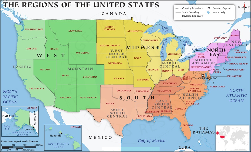
1. U.S Regions Map:
2. U.S Regions Map With States:

3. U.S Map Regions Labeled:
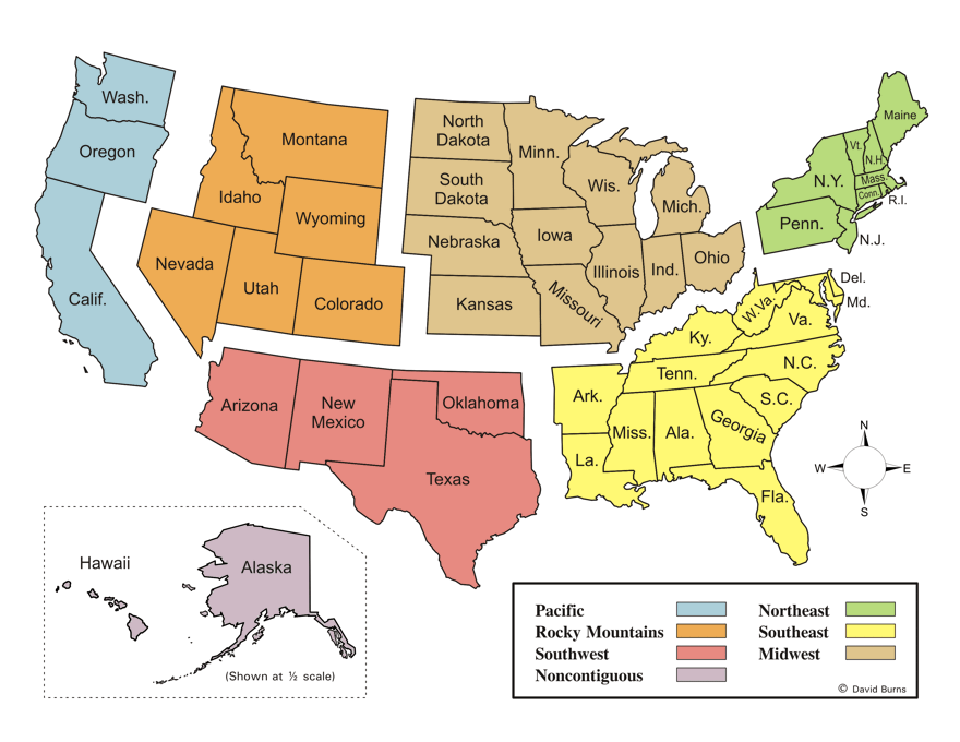
4. America Regions Map :

5. U.S Regions Map Black & White:
6. 5 U.S Regions Map:

7. Blank U.S Regions Map:

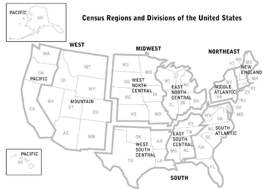
8. U.S Regions Map With All-Division:

We have defined 8 types of maps above, which you must have seen yourself. This map shows the boundaries between countries, states and counties. Each region has a distinctive culture, history, climate, geographical features, and much more. The US region map is divided into five main regions, which you can see in our list at number 6. Area maps based on different time zones, temperatures, climates, and geographic divisions can be used for further reference. The division of the five regions is as follows:
- Northeast Region
- Southwest Region
- West Region
- Southeast Region
- Midwest
All 50 US States and Their Regions
This table is useful for students and teachers who need to quickly find which region any US state belongs to. These 5 regions of the US are also shown in different divisions, which you can see in our list:
| Short Name of State | State Name | Region |
|---|---|---|
| AL | Alabama | Southeast |
| AK | Alaska | West |
| AZ | Arizona | Southwest |
| AR | Arkansas | Southeast |
| CA | California | West |
| CO | Colorado | West |
| CT | Connecticut | Northeast |
| DE | Delaware | Northeast |
| FL | Florida | Southeast |
| GA | Georgia | Southeast |
| HI | Hawaii | West |
| ID | Idaho | West |
| IL | Illinois | Midwest |
| IN | Indiana | Midwest |
| IA | Iowa | Midwest |
| KS | Kansas | Midwest |
| KY | Kentucky | Southeast |
| LA | Louisiana | Southeast |
| ME | Maine | Northeast |
| MD | Maryland | Northeast |
| MA | Massachusetts | Northeast |
| MI | Michigan | Midwest |
| MN | Minnesota | Midwest |
| MS | Mississippi | Southeast |
| MO | Missouri | Midwest |
| MT | Montana | West |
| NE | Nebraska | Midwest |
| NV | Nevada | West |
| NH | New Hampshire | Northeast |
| NJ | New Jersey | Northeast |
| NM | New Mexico | Southwest |
| NY | New York | Northeast |
| NC | North Carolina | Southeast |
| ND | North Dakota | Midwest |
| OH | Ohio | Midwest |
| OK | Oklahoma | Southwest |
| OR | Oregon | West |
| PA | Pennsylvania | Northeast |
| RI | Rhode Island | Northeast |
| SC | South Carolina | Southeast |
| SD | South Dakota | Midwest |
| TN | Tennessee | Southeast |
| TX | Texas | Southwest |
| UT | Utah | West |
| VT | Vermont | Northeast |
| VA | Virginia | Southwest |
| WA | Washington | West |
| WV | West Virginia | Southwest |
| WI | Wisconsin | Midwest |
| WY | Wyoming | West |
We have also added an image related to this list in our list above, which you can see in the 2nd position. Through these regions map of US, you can know the different climates of different regions- the Northeast region has a humid continental climate, and the northern region has cold summers. Snowfall during winter, as the temperature is below zero. On the other hand, the climate of the Southeast region is a humid subtropical climate with hot summers. In summer, the storm can reach landfall.
The climate of the Midwest region is humid continental throughout the region. Snowfall is common in winter. The climate of the southwest region is a semi-arid plain climate in the western region with a more humid climate in the east. Some areas have a desert climate. The west region has a variety of climates, including semi-arid and alpine, with Rocky Mountain and desert climates that can be found in Nevada.
The United States of America is divided into geographic regions. These regions can help describe states that have similar characteristics, such as geography, culture, and climate. Most people use five regions to describe a map of the United States territories. Including different regions, climates, subcultures, temperatures, etc. The US Census Bureau defines the US regions into 4 major regions: the Northeast, the Midwest, the South, and the West. Each state has its own time zone norms.
You can easily download all these maps on your smartphone or computer. You do not need to pay for this, all these American region maps are absolutely free for you. You have to click on the PDF button to download these images. Which is shown below every image, and download that map. We have defined all the maps according to your need. Which you can use according to your need.
All these maps are printable, and you can also take them out on a printout through the printer. These maps will be very beneficial for children and researchers. With the help of these 5 regions of the United States map, they will get information about geography, culture, and climate.
Frequently Asked Questions (FAQ)
Q1: What are the 5 regions of the United States?
The 5 regions of the United States are the Northeast, Southeast, Midwest, Southwest, and West. Each region groups states with similar geography, climate, and culture.
Q2: Which states are in the Midwest region of the USA?
The Midwest region includes Illinois, Indiana, Iowa, Kansas, Michigan, Minnesota, Missouri, Nebraska, North Dakota, Ohio, South Dakota, and Wisconsin.
Q3: How many regions does the US Census Bureau divide the United States into?
The US Census Bureau officially divides the United States into 4 regions: the Northeast, the Midwest, the South, and West. However, many schools and geography textbooks use 5 regions by dividing the South into Southeast and Southwest.
Q4: Which is the largest region in the USA by area?
The West region is the largest US region by land area, covering states like Alaska, California, Montana, and Wyoming.


