
You must have seen many of our articles, in which we have defined different types of maps. Today, our article is about the U.S. 50-state map. Those people who need a state map of the USA to find their project or state name do not need to go anywhere else. You can see below the list of maps related to these states, which we have prepared for you.
Collection of US State Maps:
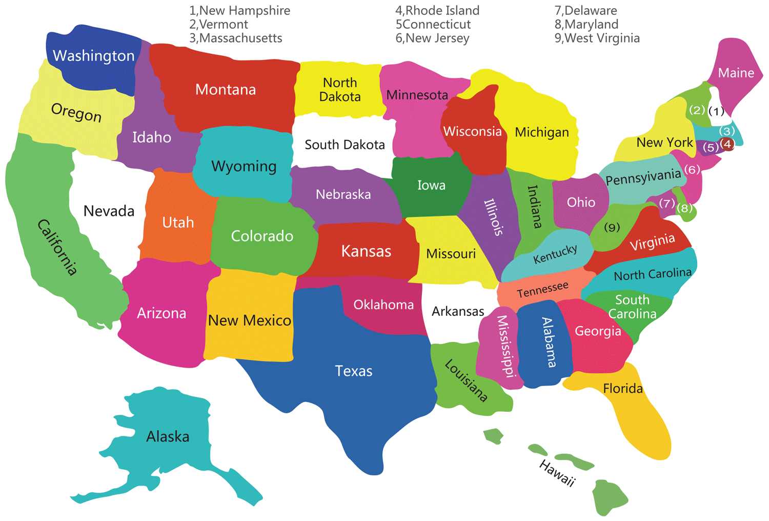
1. U.S.A Map of States :

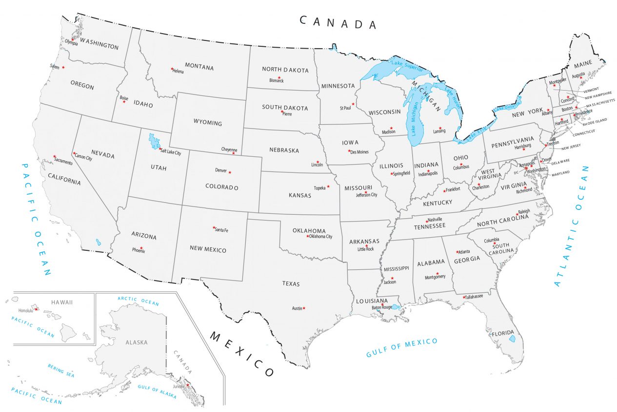
2. U.S.A State With Capital Map:

3. U.S.A State With Cities Map:

4. U.S.A Printable State Map:
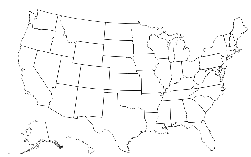
5. Blank US States Map :
6. U.S.A State Map Black and White:
7. U.S.A State outline Map:

8. U.S.A State Map With Short Name:

Everyone knows that the United States is a big country in which people of all kinds live. And they do need some maps in their daily routine. Here we have defined all the U.S. states, which you must have seen above. Maps of this type are needed either by the students or by those parents who want their children to remember the names of the states. If you are also among them, then you can download these maps according to your need. And you can take it on yourself.
We have defined 8 types of maps above. If your history teacher has given you a project or asked you to do some research on the U.S. 50 states, then you can take the help of a US map with states labeled. You will find this map at number 4 in the list, which you can easily download. And by using it in your project, you can get good marks from the teacher.
Some students remember the name of the state, but they have not yet practiced where that state is on the USA map, so you can see our image 5th. We have kept it empty so that you can convert this map into a 50-state map with names, and you can also fill in the colors in these maps according to your own. By practicing again and again, you will know which state is in which place.
Looking at the 7th image in the list, you must be wondering why it has been kept in the list. For your information, let me tell you that it is good to see the map of the USA by state; you may find this image useless. But I have kept it for those people who want to know about the boundaries of the state. Which state covers how much part, and also you can practice name filling.
For those people who want to go to the capital of the US. States, they look at different websites on Google, but they do not get their solution on those websites. If you are on our website, you can download the US state capitals map for your project because we have all kinds of maps available. You can use it according to you.
I think you must have liked my USA map state-wise images, and they are also easy to download. If you want to get these maps on your computer or smartphone, then all you have to do is click on the PDF button, from which you can easily download them in PDF format. You do not have to pay any payment to download these maps; all of them are free for you. So get them quickly and use them accordingly.
We have forgat any map of US with states, which you want, then you tell us about it through a comment. So that we can define that map as soon as possible. Do share your experience using our maps. And if any of your friends want state-wise. You can share our website with them so that they can solve their problems.
Frequently Asked Questions
Q1: How many states does the USA have?
The United States has 50 states. The most recent states to join were Alaska and Hawaii, both admitted on the same year — 1959. Delaware was the first state to join in 1787.
Q2: What is the largest US state by area?
Alaska is the largest US state by area at 663,268 square miles — more than twice the size of Texas. Rhode Island is the smallest state at just 1,545 square miles.
Q3: What is the most populous US state?
California is the most populous US state with approximately 39 million residents. Wyoming is the least populated state, with around 580,000 people.
Q4: Which US state map is best for school projects?
Map #1 (labeled state map) is best for reference. Map #5 (blank map) is best for practice tests, and Map #8 (abbreviations map) is great for learning state postal codes.


