
Today we are going to talk about a topic that separates two countries from each other. Which we all know by the name of the border or known as the international border. If you are a citizen of the United States and you want to visit its border. So you are standing at the right place because we have defined the list of US Mexico border map below.
List of United States Mexico Border Map :
1. U.S Mexico Border Map:
2. Blank US Mexico Border Map:
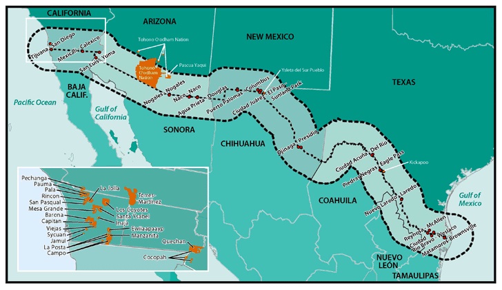
3. U.S Mexico Border Region Map:
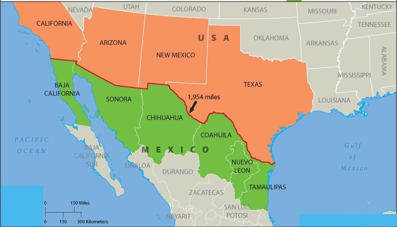
4. U.S Mexico Border State Map:
5. America Mexico Border Map :

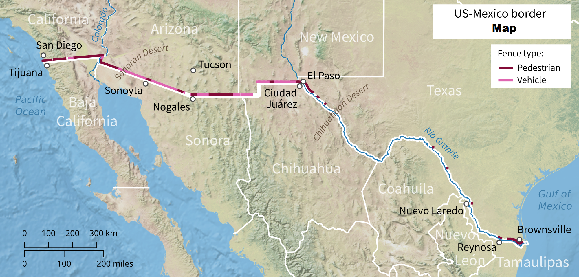
6. U.S Mexico Border White Map:

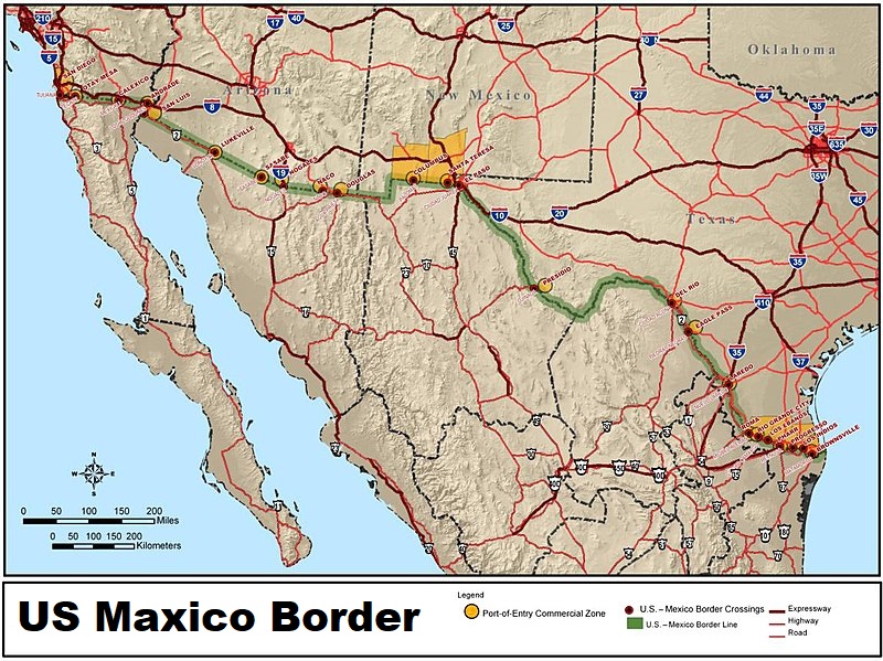
7. U.S Mexico Border Crossings Map:

8. Printable US Mexico Border Map:

9. U.S Mexico Border Route Map:

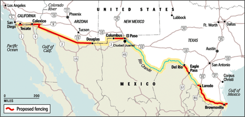
10. U.S Mexico Border Wall Map:
We have shown 10 ways to map of US Mexico border above. Which you can use according to your needs. The reasons for which it is used may vary. Because students use it in their projects, teachers use it to increase the knowledge of students and researchers in their research. Everyone has a different way of using it.
For your information, let us tell you that the border separating Mexico and the United States extends from the Pacific Ocean to the Gulf of Mexico in the west. This border passes through many states. As you can see in image 4. The Mexico-United States border is said to be the most frequently crossed border in the world.
Which is crossed by about 350 million people every year. This border is counted as the tenth-longest border in the world. The total length of this range is 3,145 km. You can get an idea of all these through our American Mexico border map. Which we have defined through the list.
It is very easy to download all these US map mexico border. Because we have made the method very easy. For that, we have mentioned the PDF button below every image. By clicking on this, you can download the map of your choice.
US States That Border Mexico
The US-Mexico border stretches 1,954 miles (3,145 km) from the Pacific Ocean to the Gulf of Mexico. Four US states share this international border:
1. California
Border length: 140 miles
Major border cities: San Diego (US) /
Tijuana (Mexico)
2. Arizona
Border length: 373 miles
Major border cities: Nogales (US) /
Nogales (Mexico), Douglas / Agua Prieta
3. New Mexico
Border length: 180 miles
Major border cities: El Paso area /
Ciudad Juárez
4. Texas
Border length: 1,254 miles (longest)
Major border cities: El Paso / Ciudad Juárez,
Laredo / Nuevo Laredo, McAllen / Reynosa,
Brownsville / Matamoros
Texas has the longest stretch of the US-Mexico border at 1,254 miles — more than all other border states combined.
Major US-Mexico Border Crossing Points
Map #7 above shows all major border crossings. The busiest crossings are:
– San Ysidro, California (busiest land border crossing in the world)
– El Paso, Texas / Ciudad Juárez
– Laredo, Texas / Nuevo Laredo
– Otay Mesa, California / Tijuana
– Nogales, Arizona / Nogales, México
All this Mexico US border map is printable. You can take the printout from the printer. If we left out a map, you need it. So you must tell us through mail or through the comment. So that we can put it in front of you as quickly as possible.
Frequently Asked Questions
Q1: How long is the US Mexico border?
The US-Mexico border is 1,954 miles (3,145 km) long, stretching from the Pacific Ocean in California to the Gulf of Mexico in Texas. It is the tenth-longest international border in the world.
Q2: Which US states share a border with Mexico?
Four US states share a border with Mexico — California, Arizona, New Mexico, and Texas. Texas has the longest stretch at 1,254 miles, followed by Arizona at 373 miles, New Mexico at 180 miles, and California at 140 miles.
Q3: What is the busiest US-Mexico border crossing?
San Ysidro in San Diego, California, is the busiest land border crossing in the world, with approximately 70,000-100,000 northbound crossings daily. The US-Mexico border overall sees about 350 million crossings per year.
Q4: Can I download these border maps for free?
Yes, all 10 maps are completely free. Click the PDF button under any map to download it.


