
People who like to travel keep roaming from one place to another such as in winter areas and summer areas. Those people should know about the temperature there before going to that place. If you are also planning to travel somewhere, then our temperature map USA will help you Through these maps, you can estimate the temperature of another place, you can see the list below from the temperature map.
Collection of The US Current Temperature Map :
1. U.S Temperature Map:

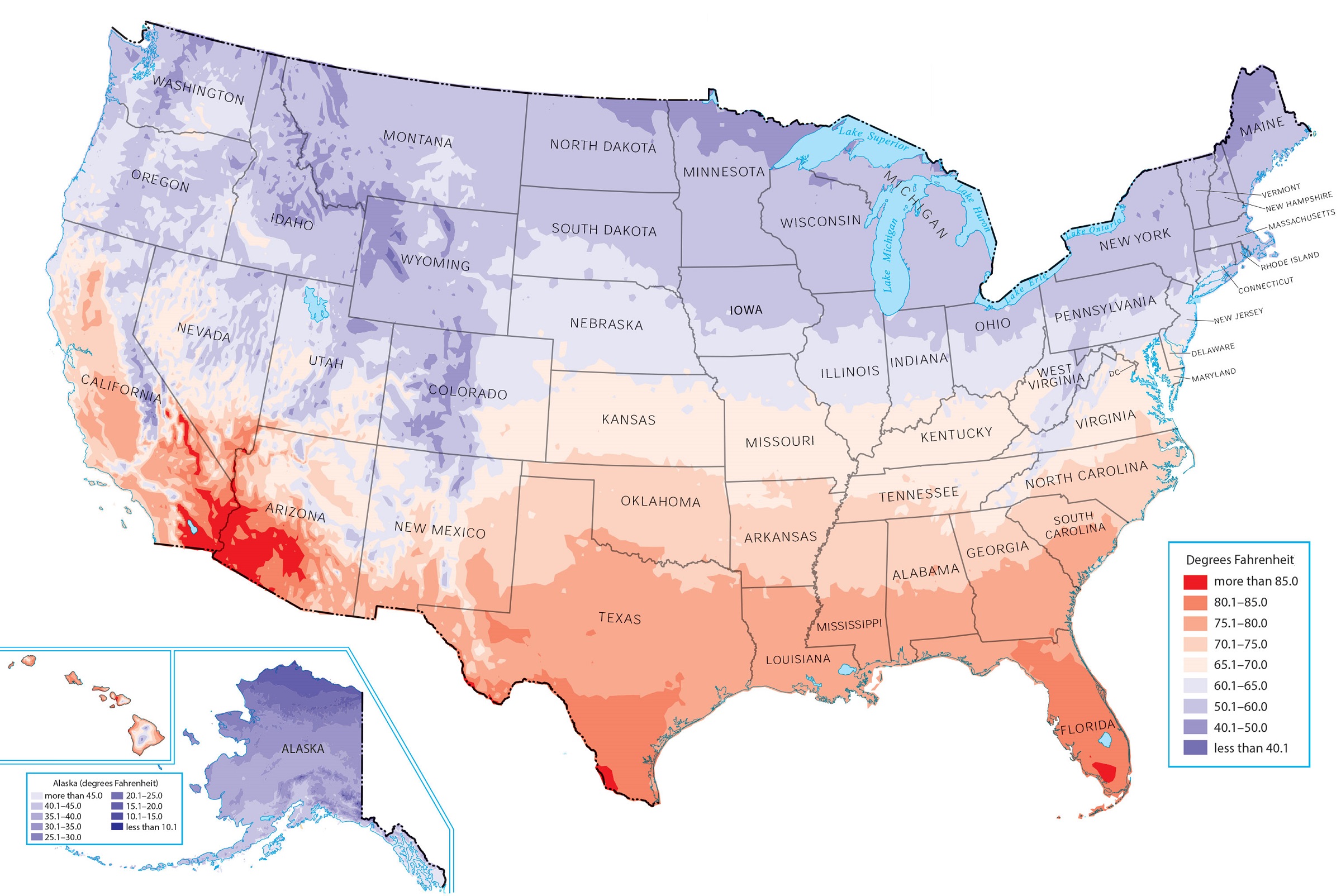
2. U.S Average Temperature Map:

3. U.S Temperature Map with State:
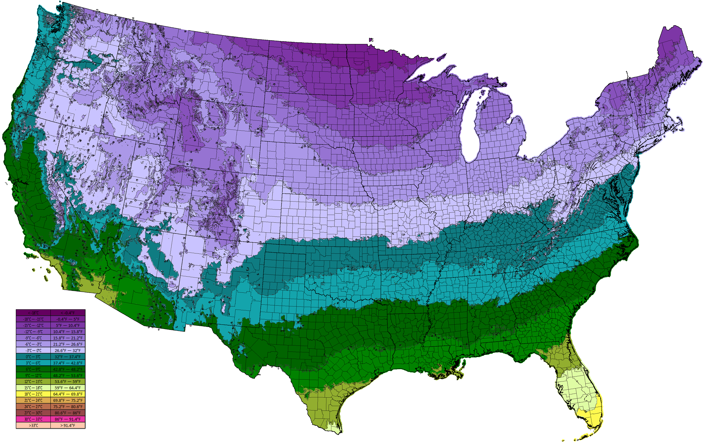
4. U.S Temperature Map 1981 to 2010:

5. Summer U.S Temperature Map:

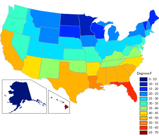
6. Winter U.S Temperature Map:
7. U.S Temperature Map All Area:
In the list shown above, we have shown the maps of 7 types in different ways. If you are a student and your teacher has given you a temperature-related project, you can use these maps for it. These maps will help you to know the temperature of your area and other areas. If you also ask to know all this, then you can see the last map in our list.
Many such people plan to roam somewhere in the current, then they will need the current US temp map. With your thinking in mind, we have already placed the temperature map in the 2nd position, so you can easily download it and plan your trip.
People who need temperature maps related to winter and summer, then you are standing at the right place because we have maps related to them, which you can use in your research and project. We have placed these maps at numbers 5th and 6th in the list. Download them and download as per your requirement.
Looking at the 4th temperature map, you must be wondering why we have kept it on our list, so let us tell you. Many times your history teacher asks you to do research on the data of previous years. To complete that research, you have to go to many libraries or buy old temperature maps from somewhere. If you are on our website, then you do not need to go anywhere; download this map and use it for your research.
Downloading these maps is very easy. All you have to do is click on the PDF button and download or print that map. You don’t have to pay anything for these temperature maps. It’s free of cost. If we’ve left out a map that you need, let us know, and we’ll deliver that map to you as soon as possible.
US Summer vs Winter Temperatures
Summer (June–August): During summer, the hottest regions in the USA are the Southwest — particularly Arizona, Nevada, and Southern California — where temperatures regularly exceed 100°F (38°C). Death Valley, California, holds the record for the highest temperature ever recorded in the US at 134°F (57°C). Use Map #5 above for
summer temperature planning.
Winter (December–February): In winter, the coldest regions are the Northern Plains and Upper Midwest — North Dakota, Minnesota, and Montana regularly see temperatures below 0°F (-18°C). The warmest winter states are Florida, Hawaii, and Southern Texas. Use Map #6 above for winter temperature reference.
Frequently Asked Questions
Q1: Which is the hottest state in the USA?
Florida and Hawaii are the hottest states in the USA by average annual temperature at around 70°F (21°C). However, Arizona experiences the most extreme summer heat, with Phoenix regularly exceeding 110°F (43°C) in July.
Q2: Which is the coldest state in the USA?
Alaska is by far the coldest US state with an average annual temperature of 27°F (-3°C). Among the contiguous 48 states, Minnesota and North Dakota are the coldest.
Q3: What is the average temperature in the USA?
The average annual temperature across the continental United States is approximately 54°F (12°C), though this varies greatly from state to state.


