
In the United States of America, 3D maps are used by most children for their school projects, these 3D maps it is easy for them to do their projects. 3D word is a common word according to today’s generation. Whether it is a matter of movies or images, people like only in 3D. If you are looking for a 3D map of USA for your projects, then you are in the right place. We have some selected maps for you, which you can see below and download according to your need.
Collection of US 3D Map :
1. 3D Map of United States:
2. Colored 3D U.S Map:

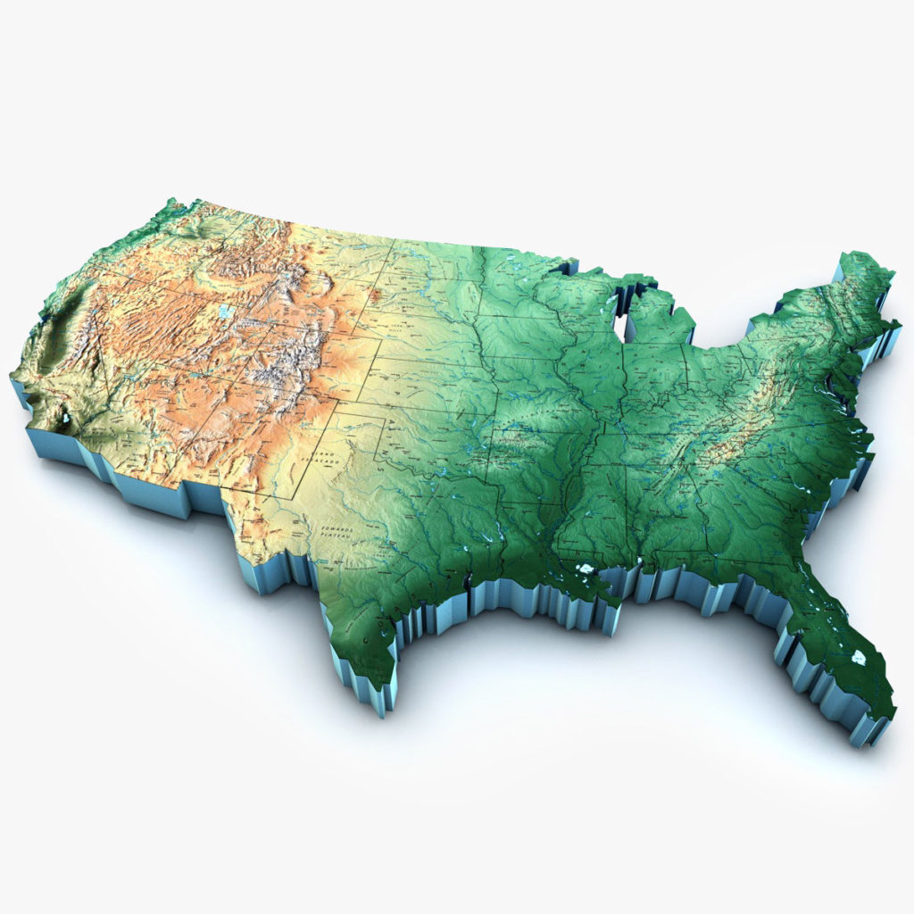
3. 3D Elevation U.S Map:

As we know, 3D maps are used for deep research and project which cannot be done in other maps. Because the 3D map image does not bursting when zoomed, whether we print or download this 3D map. This is clearly visible to us. Here we have listed 3 types of America 3D map for you 3D Map of the United States, Colored 3D US Maps, and a 3D elevation map of USA.
As you see in the first image of a 3D map of the United States of America, this is a colorful and beautiful image of a 3D US map. Which you can use for your project. In this, you can see the geographical state boundaries. And in the second 3DU.S map image you will see a colorful map. In which all the states of it have been highlighted with different colors, this map of colorful 3D will help a lot in your project. You can download it and fill in the particular states and remember them color-wise.
The third image of the 3D elevation map is an aerial view of the 3D map. It clearly shows all the mountainous and landlocked areas of the United States. You can get an idea of the depth of these mountainous areas through this map. You can choose one of these maps for your research and project and use it. You do not need to pay any payment to download these 3D maps because all these maps are free of cost. You have to click on the PDF button, then the next new tab opens in front of you, from there you can easily download and print these maps.
I hope you liked my 3D US Map Collection. Please do share these amazing map experiences with us and tell us in which project you have used these maps, and how was your project. If you have any good suggestions or want any other type of maps of the United States, then comment or let us know contact. we will solve your problem.
What is a 3D Elevation Map of the USA?
A 3D elevation map shows the physical height and depth of land across the United States. Unlike a flat map, a 3D elevation map gives you a realistic view of mountains, valleys, plains, and coastal areas. This makes it much easier to understand the geography of a region.
The United States has a highly diverse terrain. Here are the major elevation zones you will see on a 3D US map:
- Rocky Mountains (West): The highest elevations in the continental US are found here. Mount Elbert in Colorado is the highest peak at 14,440 feet above sea level.
- Appalachian Mountains (East): These are older and lower mountains running along the eastern side of the country.
Mount Mitchell in North Carolina is the highest point at 6,684 feet. - Great Plains (Center): This is a vast flat region in the middle of the country with relatively low elevation, covering states like Kansas, Nebraska, and the Dakotas.
- Coastal Plains (South & East): Low-lying flat areas along the Gulf of Mexico and Atlantic Ocean coast.
- Death Valley (California): The lowest point in the entire United States at 282 feet below sea level.
How to Use These 3D Elevation Maps
- Students & School Projects: Use Map #1 for geography projects to show the physical features of the USA in a visually impressive way.
- Research & Analysis: Map #3 (aerial 3D elevation view) is best for understanding underground and water-covered terrain areas of the US.
- Teaching: Map #2 (colored 3D map) is ideal for classroom use as different states are highlighted in different colors, making it easy to identify state boundaries alongside terrain.
To download any map, simply click the PDF button below the image. The map will open in a new tab where you can download or print it directly.
Frequently Asked Questions (FAQ)
Q1: What is the highest point in the United States?
Denali (also called Mount McKinley) in Alaska is the highest point in the United States at 20,310 feet above sea level. In the continental US, Mount Whitney in California at 14,505 feet is the highest peak.
Q2: What is the lowest elevation point in the USA?
Death Valley in California is the lowest point in the United States at 282 feet (86 meters) below sea level.
Q3: What is the difference between a 3D map and a
topographic map?
A topographic map shows elevation through contour lines on a flat surface. A 3D elevation map visually shows the terrain in three dimensions, making it easier to understand the height and depth of landforms.
Q4: Are these 3D elevation maps free to download?
Yes, all 3D maps on this page are completely free. Click the PDF button below any map image to download it.
Q5: Who uses 3D elevation maps?
3D elevation maps are used by students, researchers, geographers, urban planners, military, and travelers to understand the physical terrain of the United States.


