
The United States of America is one of the largest countries in the world, which has 50 states, about which we have already told you. If you are looking for a US cities map to know your project or name then you are in the right place because we have given the below table related to them. In this, you will find 7 types of cities map. Which you can download and complete your project.
Collection of the America map with cities :
1. U.S Cities Map:
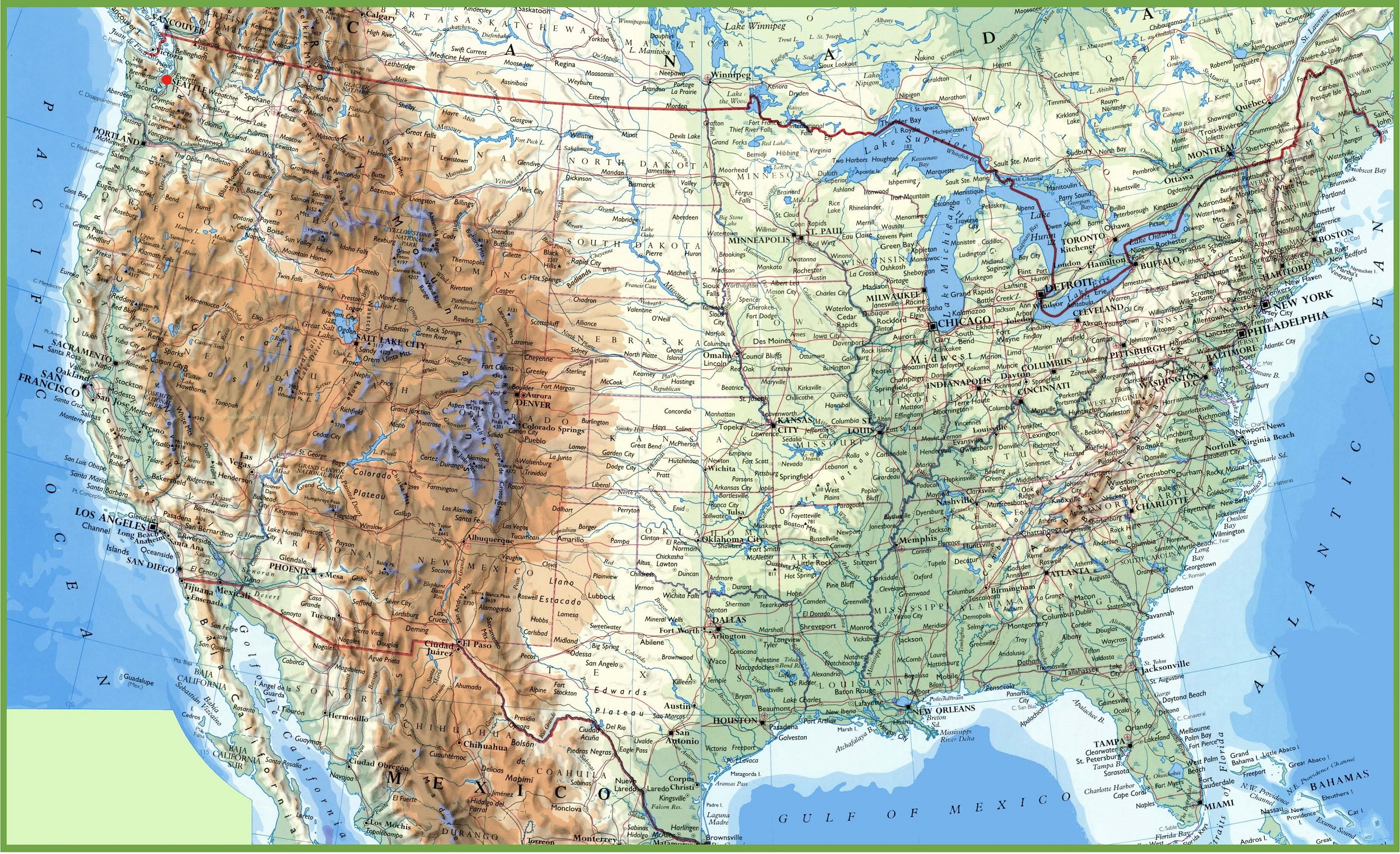
2. U.S Large Cities Map:
3. U.S Cities with States Map:
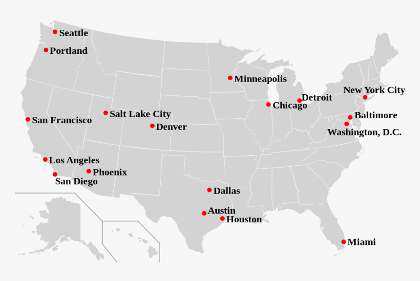
4. U.S Map with Major Cities :
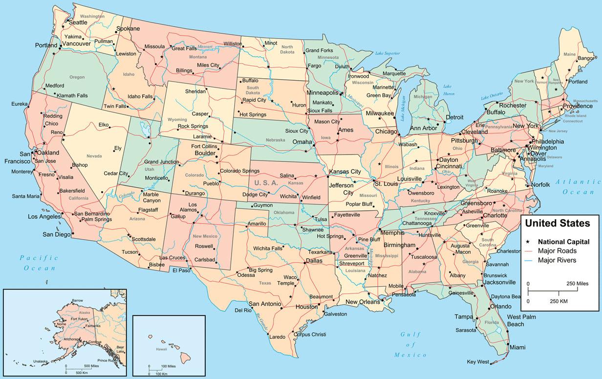
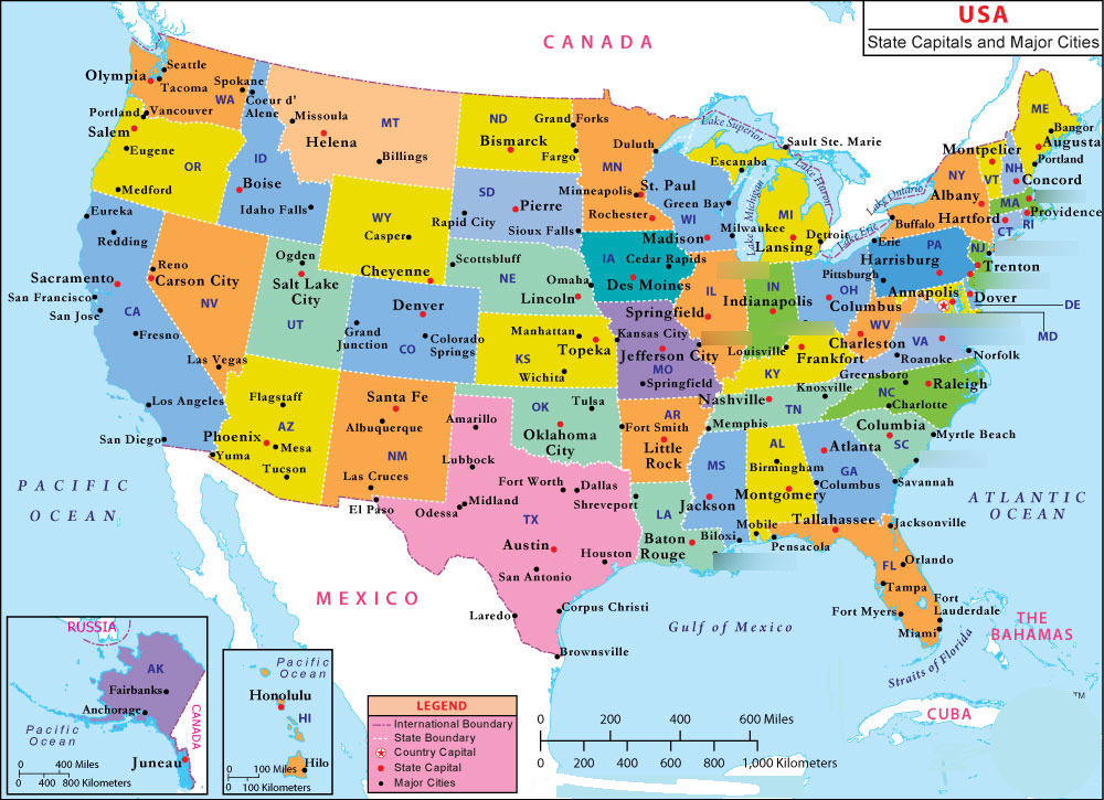
5. U.S Cities with Capital Map:
6. U.S All Cities Map:
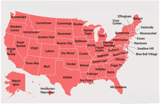
7. U.S Cities Town Map:
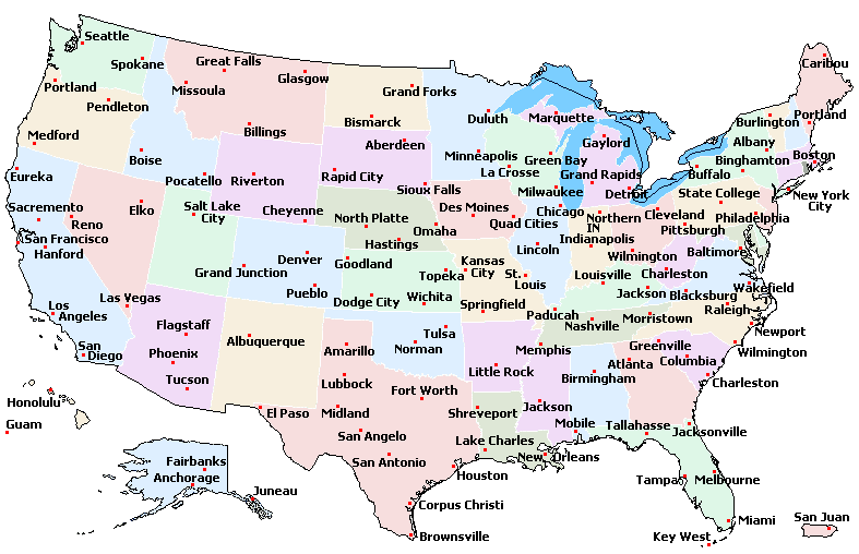
Not everyone knows the names of most cities; there are some people who know the names of their cities because they live in that city. If you want to know what is the names of other cities that are near our city. So you don’t need to go anywhere else. We will help you to know the names of the cities. You can see our 6th image. This map of the USA shows cities.
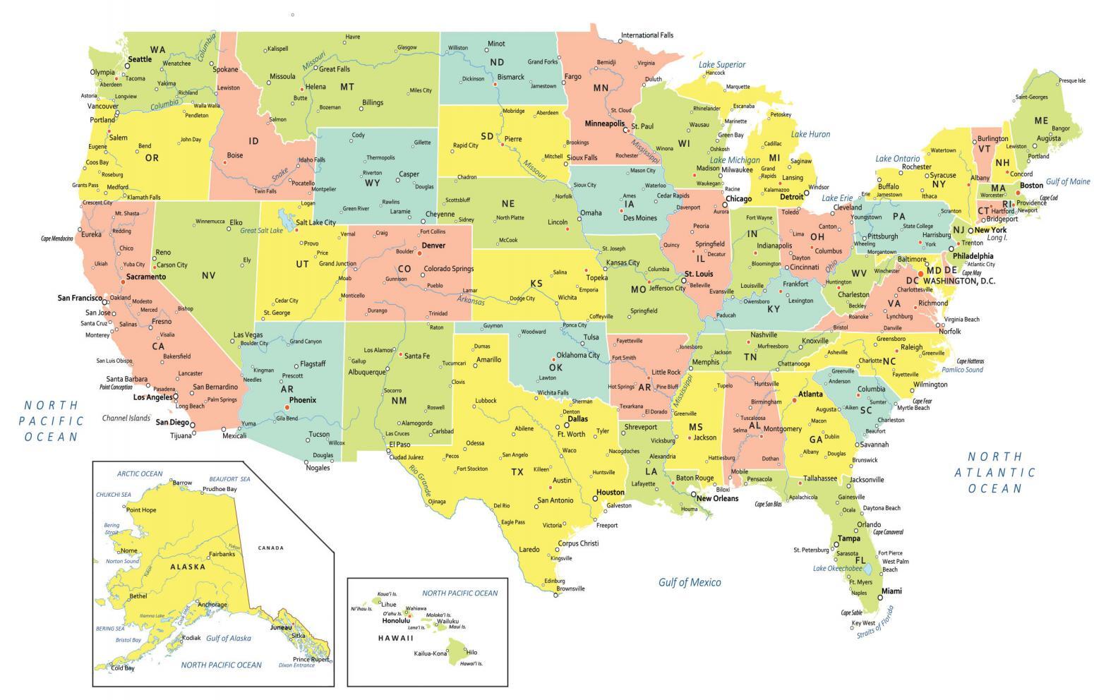
Many times, we also get to see that people are curious to know how many cities are in the state in which we have lived, and what the names of those cities are. Then, you can see the USA map with states and cities. Which we have shown in the table in the 3rd position. In this, we have shown the separate state-wise to each city, which will make it easy for you to know the name.
In the United States of America, when teachers give children a project to research the town. Children get confused about knowing how to research the town and whom to add to their project, so we have the solution to their confusion. They can see the 7th image in our table and download it, and complete their project.
In a subject like history, teachers ask children many questions related to states and cities, like how many cities are there in the U.S.A, which is the major city of the USA, and which is the biggest city in the USA. You do not need to be under stress, just remember the name of our website because we have solved all the problems related to maps. The answer to the questions asked is in our list, which you can see on the 2nd, 4th, and 6th numbers.
It is very easy to download these maps; you have to click on the PDF button, from which you can get that map in pdf format. We will not charge you anything for these maps. Because we are providing you with all these maps for free. If you want the US capital cities map, then we have placed it at number 5th. We have put a PDF button at the bottom of each image. So that you can download that map according to your needs.
I think you might have liked my USA map major cities and towns article. You share this article with those people who want to know the names of cities.
Top 25 Largest Cities in the USA by Population
| Rank | City | State | Population |
| 1 | New York City | New York | 8,336,817 |
| 2 | Los Angeles | California | 3,979,576 |
| 3 | Chicago | Illinois | 2,693,976 |
| 4 | Houston | Texas | 2,304,580 |
| 5 | Phoenix | Arizona | 1,608,139 |
| 6 | Philadelphia | Pennsylvania | 1,603,797 |
| 7 | San Antonio | Texas | 1,434,625 |
| 8 | San Diego | California | 1,386,932 |
| 9 | Dallas | Texas | 1,304,379 |
| 10 | San Jose | California | 1,013,240 |
| 11 | Austin | Texas | 978,908 |
| 12 | Jacksonville | Florida | 949,611 |
| 13 | Fort Worth | Texas | 918,915 |
| 14 | Columbus | Ohio | 905,748 |
| 15 | Charlotte | North Carolina | 874,579 |
| 16 | Indianapolis | Indiana | 887,642 |
| 17 | San Francisco | California | 873,965 |
| 18 | Seattle | Washington | 737,255 |
| 19 | Denver | Colorado | 715,522 |
| 20 | Nashville | Tennessee | 689,447 |
| 21 | Oklahoma City | Oklahoma | 681,054 |
| 22 | El Paso | Texas | 678,815 |
| 23 | Washington D.C. | D.C. | 689,545 |
| 24 | Las Vegas | Nevada | 641,903 |
| 25 | Louisville | Kentucky | 633,045 |
All these major cities are visible on Map #4 (US Map with Major Cities) above.
Major US Cities by Region
- Northeast: New York City, Philadelphia, Boston, Baltimore, Pittsburgh
- Southeast: Miami, Atlanta, Charlotte, Jacksonville, Nashville, Tampa
- Midwest: Chicago, Columbus, Indianapolis, Detroit, Milwaukee, Kansas City
- Southwest: Houston, San Antonio, Dallas, Phoenix, El Paso, Las Vegas
- West: Los Angeles, San Diego, San Francisco, Seattle, Denver, Portland
Frequently Asked Questions
Q1: What is the largest city in the USA?
New York City is the largest city in the USA with a population of over 8.3 million people. The greater New York metropolitan area has a population of over 20 million.
Q2: Which US state has the most cities?
Texas has the most incorporated cities of any US state, with over 1,200 cities. California and Illinois also have large numbers of cities.
Q3: What is the difference between a city and a town in the USA?
In the USA, a city is generally a larger, incorporated municipality with its own government. A town is typically smaller. The exact definitions vary by state — some states have no legal distinction between cities and towns.
Q4: Which map shows all US cities?
Map #6 (US All Cities Map) shows the most comprehensive view of all cities across the United States. Map #4 focuses on major cities only, making it easier to read.


